Corporate Profile Staff Links
Services
Equipment
Vessels
Projects
Clients
Contact


Arctic Surveys


    Arctic Project

Each open water season, Nearshore and Wetlands Surveys participates is a diverse assortment of projects in the Alaskan Arctic.  These projects include:

  • Multibeam, single beam, and sidescan sonar surveys,
  • Site clearance, pipeline route, and shoal mapping,
  • Coastal protection inspection and evaluation,
  • Bluff erosion studies, and
  • Construction monitoring


Beach Profile Surveys


    Project-Beach Nearshore and Wetlands Surveys is active in monitoring and studying coastal processes in Southern California.  They conduct numerous beach profile surveys each
year.  Profile data is obtained from the back beach,
across the upper beach, through the surf zone, and offshore beyond the depth of closure.  The use of specialized topographic and bathymetric techniques, developed over years of experience, result in
continuous data with no gap through the dynamic
surf zone.


Consulting


    McFaddin National Wildlife Refuge

Nearshore and Wetlands Surveys assisted LEAP Engineering, LLC in designing and initiating a beach profile survey program along the McFaddin National Wildlife Refuge in Jefferson County, TX.  The area has been adversely affected by numerous hurricanes in the past two decades.  Beach erosion has forced the closure of the only road between Bolivar Peninsula and Port Arthur and threatens the freshwater marsh with salt water intrusion.  The survey program will extend the work of Dr. Billy Edge, Texas A & M University.


    Arctic Gravel

Nearshore and Wetlands Surveys personnel
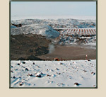
recently provided on-site representation during the construction of a $15M, 8-acre, offshore arctic gravel island.  The representative managed a 6-person team of inspectors and was responsible for daily reporting and technical, environmental, and permit compliance.

Nearshore and Wetlands Surveys frequently consults
with the USACE, ERDC and assist a team of divers maintaining an array of wave and water level
recorders in and around the LA/LB Harbor Complex. 
The data from the instruments are used to calibrate physical and numerical models.


Lakes, Rivers and Wetlands


    Project Ballona

A water level and salinity study of the Ballona
Wetland was undertaken to assess the effectiveness
of tide gates that allow partial tidal inundation of
the basin.  The study determined that water
continued to flow into the basin from an unknown
source afer the tide gates closed.


    Salt River Project

A bathymetric survey of the Eel River near the
confluence of the Salt River in Humboldt County was conducted.  The data will be combined with aerial photogrammetry data to study causes and possible solutions to frequent flooding of the Salt River.


    City of Lake Elsinore

The City of Lake Elsinore maintains a boat launch facility in Lake Elsinore.  The facility was designed and constructed during a period of low water levels.  Recent high water levels have forced the facility to curtail operations.  A study is underway to redesign the facility to make it operational over a wider range of water levels and to provide for in-water mooring of vessels.  A bathymetric survey was undertaken to map the lake bottom near the facility.  Submerged and partially submerged bushes and trees complicated the data collection.


Marina Surveys


    Mapping Eel Grass Beds

Working with Coastal Resources Management, Inc., Nearshore and Wetland Surveys has developed a technique to accurately and efficiently map eel grass beds in harbors and marinas.  The technique combines side scan sonar imaging with concurrent video documentation and target confirmation.  The side scan mosaic is imported into a GIS program to allow for calculation of habitat area and monitor changes over time.


    Channel Island Harbor

Small boat marinas are difficult to survey because the boats and docks obscure much of the survey area.  Nearshore and Wetlands Surveys has created software that allows the use of an acoustic profiler to extend the survey area beyond that can be covered with a traditional bathymetric survey.  The rotating head of the profile allows sounding data to be collected abeam of the survey vessel and under boats and floating docks.  This technique has been used to map marinas in Channel Island Harbor, San Diego Harbor, and elsewhere.


Port and Harbor Facilities Surveys

 
    Multibeam
  • A multibeam sonar was used to completely
    map a ship basin in San Diego Harbor. 
    The mapping was a crucial step in
    maintaining Navy certification for
    use of the shipyard.
 
 
  • Site condition surveys were conducted at the US Coast Guard Stations in San Francisco and San Diego including mapping of submerged rock revetments and a disused amphibious plane ramp.  The data was used for the design of needed upgrades to the facilities.
  • A single beam bathymetric survey was conducted at the GP Gypsum facility in the Port of Long Beach to study the extent of shoaling near the their dock, which had curtailed their loading operations to periods of high tide.
  • A fluorescent dye study was conducted to test the effectiveness of pumps to improve circulation at Baby Beach in Dana Point Harbor.  High bacteria levels frequently cause closure of the popular area.
 
         
Home Page